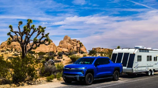
Support CleanTechnica's work through a Substack subscription or on Stripe. A couple of years ago, I wrote an article titled “We May Have Been Wrong To Mock GM’s Big Battery Approach To Electric Trucks.” Back then, it was incredibly easy to point and laugh at vehicles like the Hummer EV ... [continued]
Any decent trip planner is going to account for headwinds.
Headwinds are a weather thing. They can change dramatically at any moment. Trip planers only guestimate that kind of thing. And with a trailer having the arodynamics of a kite, they have a much greater effect on the trailer.
The 10% arrival accounts for margins of error in those calculations.
Only given the make and model you entered. The flying rectangle you’re towing isn’t part of those calculations. So it’ll have additional drag from the start, eating up that margin of error quickly.
It’s a gusstimate until you start driving. Then it might get real time data from the vehicle performance, not the weather. And only if you can give it access to the vehicle data. If the guesstimate is too far off, and there aren’t any closer chargers, your route planer gets you stranded.
In the article they discovered this, and had to give the route planner false data until its guesstimates lined up with their real results.
It’s a gusstimate until you start driving. Then it might get real time data from the vehicle performance not the weather.
Wrong. It gets it from weather reports. If they used something else in their testing, that’s their mistake, and no one will force you to make it as well.
That’s an estimate, not a guesstimate. It’s based on actual data. Which is obviously not what you were referring to. You specifically said “not the weather”.
That’s what a guesstimate is. A guess based on some actual data that’s still not all that reliable. It’s a bit of word play that acts as a reminder that an estimate is often wrong.
We account for wind speed and temperature changes that impact your range in real-time.
Tell me what they’re talking about. Because that’s just generic marketing speak. What’s it actually mean? How’s that work, exactly?
Tell me what they’re talking about. Because that’s just generic marketing speak.
What? LOL this is not complicated. They take wind speeds from weather reports and estimate the impact on efficiency using the known aerodynamics of the vehicle.
Are they current conditions or forcasts? General areas, or specific to the roads? Do they take into account the effects of surrounding buildings or tree cover, angles of attack relative to various sections of road? Do they specifically calculate based on vehicle drag coefficient or just a standard percentage range impact? Do they have not only vehicle drag, but vehicle and trailer combinations for various sizes and shapes and weights of trailer?
Those are just off the top of my head.
But none if this really matters. Your original idea of having 150miles of range between charging stops on long trips is already smashed down by over 60 miles. This is literally nibbles on maybe a few percent.


Headwinds are a weather thing. They can change dramatically at any moment. Trip planers only guestimate that kind of thing. And with a trailer having the arodynamics of a kite, they have a much greater effect on the trailer.
Only given the make and model you entered. The flying rectangle you’re towing isn’t part of those calculations. So it’ll have additional drag from the start, eating up that margin of error quickly.
All of this was covered in the article.
Trip planners do not “guesstimate”, they tap into realtime data.
The trailer is covered in the estimate as well.
Once again, I don’t need to read a third hand account about this. I’ve lived it.
It’s a gusstimate until you start driving. Then it might get real time data from the vehicle performance, not the weather. And only if you can give it access to the vehicle data. If the guesstimate is too far off, and there aren’t any closer chargers, your route planer gets you stranded.
In the article they discovered this, and had to give the route planner false data until its guesstimates lined up with their real results.
Wrong. It gets it from weather reports. If they used something else in their testing, that’s their mistake, and no one will force you to make it as well.
Weather reports themselves are a guesstimate. You can’t precisely predict the specific gusts in a specific spot on a specific road.
They were using ABRP as they knew GMaps sucked for this.
That’s an estimate, not a guesstimate. It’s based on actual data. Which is obviously not what you were referring to. You specifically said “not the weather”.
Then either you or they don’t know what they’re talking about.
That’s what a guesstimate is. A guess based on some actual data that’s still not all that reliable. It’s a bit of word play that acts as a reminder that an estimate is often wrong.
Tell me what they’re talking about. Because that’s just generic marketing speak. What’s it actually mean? How’s that work, exactly?
What? LOL this is not complicated. They take wind speeds from weather reports and estimate the impact on efficiency using the known aerodynamics of the vehicle.
That’s not realy any more information.
Are they current conditions or forcasts? General areas, or specific to the roads? Do they take into account the effects of surrounding buildings or tree cover, angles of attack relative to various sections of road? Do they specifically calculate based on vehicle drag coefficient or just a standard percentage range impact? Do they have not only vehicle drag, but vehicle and trailer combinations for various sizes and shapes and weights of trailer?
Those are just off the top of my head.
But none if this really matters. Your original idea of having 150miles of range between charging stops on long trips is already smashed down by over 60 miles. This is literally nibbles on maybe a few percent.